Wikipedia
This text was copied from Wikipedia on 22 July 2024 at 3:10AM.
| Greenwich Park | |
|---|---|
 View of the Queen's House at centre and Canary Wharf from Greenwich Park | |
  Greenwich Park Location in Greenwich | |
| Type | Public park |
| Location | London, SE10 |
| Coordinates | 51°28′38″N 0°00′00″E / 51.4773°N 0.0000°E / 51.4773; 0.0000 |
| Area | 74.5 hectares (184 acres) |
| Operated by | The Royal Parks |
| Public transit access |  Greenwich Greenwich |
| Website | Official website |
Greenwich Park is a former hunting park in Greenwich and one of the largest single green spaces in south-east London. One of the Royal Parks of London, and the first to be enclosed (in 1433), it covers 74 hectares (180 acres),[1] and is part of the Greenwich World Heritage Site. Surrounding the hilltop Royal Observatory (opened in 1676) and straddling the Greenwich Prime Meridian, it commands elevated views over the River Thames, the Isle of Dogs and the City of London.
The park is open year-round, and incorporates flower gardens as well as grassy spaces, a children's playground, cafés and other amenities, a bandstand, a boating lake, a pond, wooded areas, and a wildlife habitat called 'The Wilderness'. The park also contains Roman and Anglo-Saxon remains, and is listed Grade I on the Register of Historic Parks and Gardens;[2] in 2020, it was awarded a National Lottery grant to restore historic features and add new visitor facilities.[3] It hosted Olympic and Paralympic equestrian events during the London 2012 Summer Olympics, and accommodates runners prior to the start of the annual London Marathon.
History
15th–18th centuries
The estate of some 200 acres (81 ha) was originally owned by Saint Peter's Abbey, Ghent, but reverted to the Crown in 1427 and was given by Henry VI to his uncle Humphrey, Duke of Gloucester.[4] He built a house by the river, Bella Court, and a small castle, called Greenwich Castle or Duke Humphrey's Tower, on the hill. The former evolved first into the Tudor Palace of Placentia and then into the Queen's House and Greenwich Hospital. Greenwich Castle, by now in disrepair, was chosen for the site of the Royal Observatory by Charles II in 1675, on the advice of Sir Christopher Wren.
As a result of this decision, the Greenwich Prime Meridian crosses Greenwich Park, passing due north and south of the Royal Observatory. A stainless steel strip in the Observatory's courtyard marks the line; it is also marked on the wall of a path just north of the Observatory and there are wall plaques just outside the park, in Chesterfield Walk to the south and Park Vista to the north. In 1884 it was agreed to be the official Prime Meridian of the world, a status it held for a century until it was superseded by the related IERS Reference Meridian, which runs parallel to the Greenwich Meridian some 102 metres to its east.[5]
In the 15th century the park was mostly heathland and probably used for hawking. In the next century, deer were introduced by Henry VIII for hunting, and a small collection of deer was maintained in an area to the south east. James I enclosed the park with a brick wall, 12 feet (3.7 m) high and two miles (3 km) long at a cost of £2000, much of which remains and defines the modern boundary. A small section of the boundary wall in the southwest corner of the park was formerly part of Montagu House, one time residence of Caroline of Brunswick, demolished in 1815,[6] though Queen Caroline's bath (c. 1806) is preserved inside the park. James I also commissioned the first modern ice house in 1619 in the Park.[7]
In the 17th century, the park was landscaped, possibly by André Le Nôtre who is known at least to have designed plans for it.[8] The public were first allowed into the park during the 18th century. Samuel Johnson visited the park in 1763 and commented "Is it not fine?". From 1730 to 1857, around 250,000 Londoners would attend the bi-annual Greenwich fair (held on May Day and Whitsun); Observatory Hill and nearby One Tree Hill were used on public holidays for mass 'tumbling'.[9][10]
1800–present day


In the 1830s a railway was nearly driven through the middle of the lower park on a viaduct but the scheme was defeated by intense local opposition. However, the London and Greenwich Railway was later extended beneath the ground via a cut-and-cover tunnel link between Greenwich and Maze Hill which opened in 1878 (the tunnel alignment is on the north side of the park's northern boundary wall, running beneath the gardens of the National Maritime Museum and Queen's House).
In 1888 the park got a station of its own when Greenwich Park railway station was opened. The station was not successful, with most passengers preferring the older Greenwich station, and in 1917 Greenwich Park station and the associated line closed.
On 15 February 1894, a man died after a bomb explosion in Greenwich Park, close to the Observatory. The victim, Martial Bourdin, was a 26-year-old Frenchman with links to the anarchist Club Autonomie, and was carrying the device when it exploded prematurely. The incident inspired Joseph Conrad's The Secret Agent.[11]
During the two World Wars, allotments were sited on the northern edge of the park, south of the Queen's House. Agreement for 139 plots for local families to grow vegetables was reached in March 1918, with tenants paying 7s 6d a year each for their plots. Tenants kept their allotments until February 1921 when the park returned to its former use. From 1939, the park was again used for wartime allotments.[12] During World War II anti-aircraft guns were positioned in the park’s flower garden with some tree tops removed to clear the line of fire.[13]
During the London 2012 Summer Olympics, Greenwich Park was the venue for the Olympic equestrian events and for the riding and running parts of the modern pentathlon events. It was also the venue for the Paralympic equestrian events.[14] The use of Greenwich Park for Olympic equestrian events had earlier caused some tension between the London Organising Committee for the Olympic and Paralympic Games 2012 (LOCOG) and some local area residents. A community action group, NOGOE (No to Greenwich Olympic Equestrian Events), believed Greenwich Park was not a suitable venue for the events and started an (ultimately unsuccessful) petition to get the equestrian events relocated; by February 2009 this had gathered over 12,000 signatures.[15] Olympic use of the park was approved by Greenwich Council in March 2010,[16] with test events held the following year.[17]
In 2021, a £12 million four-year project, 'Greenwich Park Revealed', was instigated to reveal, restore, protect and enhance the park's past and current features, enhance the park's biodiversity, and provide better access for people with disabilities.[3] Supported by a grant of £4,517,300 from the National Lottery Heritage Fund and the National Lottery Community Fund,[3][18] the project will remodel the area around the General Wolfe statue viewpoint,[19] restore the 'Grand Ascent' (a series of giant grass steps, north of the Wolfe statue),[8] restore other landscape features, replant tree avenues,[20] and add a £1.2m learning centre (designed by Architype),[21] a café and other visitor facilities.[22][23] Several archaeological investigations have been undertaken in parallel with the work, including 2021 and 2022 digs of a Saxon burial mound, a 2023 dig on the site of the 'Grand Ascent', a community excavation of a World War II air-raid shelter east of One Tree Hill, and exploration of the remains of John Pond’s Magnetic Observatory,[24] an enclosure built in 1817 to analyse Earth's magnetic field.[10]
Geography
The park is roughly rectangular in plan with sides 1000 metres by 750 metres and oriented with the long sides lying NNW to SSE. In what follows this direction is taken to be N to S for ease of exposition. It is located at grid reference TQ390772.
The park is on two levels, with a number of dips and gullies marking the transition between them. The lower level (closest to the National Maritime Museum, Queen's House and, beyond them, the Thames) lies to the north; from there a steep walk uphill reveals the southern part – a flat expanse that is, essentially, an enclosed extension of the plateau of Blackheath.
Roughly in the centre, on the top of the hill, is the Royal Observatory and a statue of General James Wolfe (Simon Jenkins rated the view of the Royal Hospital with Canary Wharf in the distance as one of the top ten in England).[25] At the northern edge is the National Maritime Museum and Queen's House, and beyond those Greenwich Hospital. To the east is Vanbrugh Castle. To the south is Blackheath and in the south-western corner is the Ranger's House, looking out over the heath. To the west lie the architecturally fine streets of Chesterfield Walk and Croom's Hill.[26]

Royal Observatory

The Observatory is on the top of the hill. Outside is a statue of General James Wolfe (buried in St Alfege Church, Greenwich) in a small plaza from which there are views across to the former Greenwich Hospital (the Old Royal Naval College, now the University of Greenwich) and then towards the river, the skyscrapers of Canary Wharf, the City of London to the northwest and The O2 Arena to the north.
Amenities

On the lower level of the park there is a popular children's playground (north-east corner, close to Maze Hill railway station), an adjacent boating lake, and a small orchard ('The Queen's Orchard'). There is also a herb garden (close by entrance to Greenwich town centre).
On the upper level, there is an extensive flower garden with a large duck pond, a rose garden, a cricket pitch, tennis courts, a bandstand, Roman remains, an ancient oak tree (known as Queen Elizabeth's Oak, associated with Queen Elizabeth I)[27][28] many 17th-century sweet chestnut trees with gnarled, swirling trunks, an enclosure ('The Wilderness') used to house wild deer,[29] and an avenue of cherry trees renowned for their spring blossoms.[30][31]
West of the Observatory is the garden of the former Astronomer Royal, a peaceful secluded space which is good for picnics and also sometimes used by theatre groups (Midsummer Night's Dream, etc.). On the opposite side (southeast of the Wolfe statue) is the Pavilion Café. There is another, smaller café by the north-west gate, and a snack bar in the children's playground; in March 2024, as part of the 'Greenwich Park Revealed' programme, the Ignatius Sancho Café was opened in a refurbished building by the Vanbrugh Gate on the east side of the park.[32][33]
It is possible to park (pay and display) in areas along the main roads entering from Blackheath (though it can be busy).[34] Cycle routes criss-cross the park (as do runners, roller-bladers, dog-walkers, etc.). Until 2020, other road traffic (cars and motor-cycles) could use the park road linking Blackheath and Greenwich at peak periods on weekdays. After a trial closure, the road was permanently closed to through traffic in 2022.[35]
Sport

One of three start points for the London Marathon, the 'red start', is located just south of Greenwich Park, in Charlton Way, with runners held in the park before they start.[36] A London half marathon, Run to the Beat, passed through the park from 2008 to 2012; in 2013, the last running of the 13.1-mile event started and finished in the park.[37] Since 2018 the park has also accommodated some of the finish facilities of The Big Half, a half marathon run each September. A 2.62-miles charity 'mini marathon' for children is held each May,[38] and the park also hosts occasional commercially organised 5km and 10km running events.[a]
The park also staged the start of the final stage of the 2006 Tour of Britain cycle race (3 September).
A cricket pitch is maintained in the southwest corner of the park, with an adjacent pavilion. Tennis courts are located to the north of the cricket pitch.
Greenwich Park in popular culture
Greenwich Park was used for outdoor London scenes including representing the Constitution Hill thoroughfare in the 2009 film The Young Victoria starring Emily Blunt and Rupert Friend.
Gallery
-
 Late 17th or early 18th-century conduit house
 -
![Henry Moore sculpture[40]](//upload.wikimedia.org/wikipedia/commons/thumb/7/7f/The_Henry_Moore_Sculpture_in_Greenwich_Park.jpg/297px-The_Henry_Moore_Sculpture_in_Greenwich_Park.jpg) Henry Moore sculpture[40]
Henry Moore sculpture[40] -
 One of the ancient sweet chestnut trees, with distinctive spiralling bark
 -

-

-
 View of the City of London (right) and The Shard (left) from Greenwich Park
 -
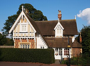 Lodge at the south entrance
 -
 Early medieval burial mounds in Greenwich Park
 -
 The Motherstone, a spring-fed drinking fountain in Greenwich Park
 -
 "Queen Elizabeth's Oak"
 -
 Greenwich Park Flower Garden
 -
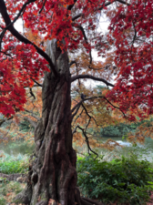 Acer Palmatum, Japanese Maple
 -
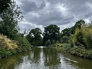 Greenwich Park Pond
.jpg)
![Henry Moore sculpture[40]](http://en.wikipedia.org/wiki/File:The_Henry_Moore_Sculpture_in_Greenwich_Park.jpg)


.jpg)


.jpg)


Notes and references
- ^ Greenwich Park does not host a parkrun; the nearest weekly parkrun is at Charlton Park while 'Greenwich parkrun' - the borough's first parkrun, established in 2010 - is at Avery Hill.[39]
- ^ "Greenwich Park". The Royal Parks. Archived from the original on 3 April 2012. Retrieved 4 August 2012.
- ^ Historic England, "Greenwich Park (1000174)", National Heritage List for England, retrieved 13 November 2017
- ^ a b c "Greenwich Park receives National Lottery millions to protect World Heritage Site". The Royal Parks. 15 January 2020. Retrieved 6 September 2020.
- ^ (Barker 1999)
- ^ "The Prime Meridian is unmoved". Royal Museums Greenwich. Retrieved 3 April 2024.
- ^ "View of Park Corner House (part of Montagu House), Blackheath, seen among trees". Royal Museums Greenwich. Retrieved 3 January 2018.
- ^ "The ice house uncovered". Country Life. 4 October 2010. Retrieved 26 July 2022.
- ^ a b Gerrard, Neil (12 September 2022). "The Royal Parks to restore Greenwich Park's giant grass steps". Construction Management. Retrieved 3 April 2024.
- ^ Cavendish, Dominic (18 June 2011). "Greenwich Fair: Where Dickens let his hair down". Daily Telegraph. Retrieved 1 July 2021.
- ^ a b Howard, Sally (10 December 2023). "Wild beasts and Charles II: amateur army digs for history in British parks and gardens". Observer. Retrieved 5 April 2024.
- ^ Higgitt, Rebekah (5 August 2016). "The real story of the Secret Agent and the Greenwich Observatory bombing". Guardian. Retrieved 3 April 2024.
- ^ "Cabbages or Cricket: the Fight for Greenwich Park's World War 1 Allotments". Friends of Greenwich Park: Greenwich Park History. Retrieved 5 April 2024.
- ^ "View of London from Greenwich Park". Government Art Collection. Retrieved 5 April 2024.
- ^ "Greenwich Park". Inside The Games. 29 August 2011. Retrieved 3 April 2024.
- ^ Beard, Mathew (7 October 2009). "Dennis is a menace to 2012 equestrian plans". This is London. Retrieved 1 August 2010.
- ^ Gibson, Owen (23 March 2010). "London Olympics row over Greenwich Park role reaches climax". Guardian. Retrieved 3 April 2024.
- ^ Jeavans, Christine (5 July 2011). "London 2012: Testing Greenwich Park's Olympic venue". BBC News. Retrieved 3 April 2024.
- ^ Taylor, Tallulah (12 March 2021). "Greenwich Park to get £8 Million facelift funded by National Lottery". London News Online. Retrieved 3 April 2024.
- ^ Cunningham, Ed (1 November 2023). "Greenwich Park is getting a spectacular new viewing platform". Time Out. Retrieved 3 April 2024.
- ^ Vann, Bethany (2 November 2023). "Phase two set to begin of Greenwich Park restoration". ProLandscaper. Retrieved 3 April 2024.
- ^ Youde, Kate (19 August 2019). "Architype's design for Greenwich Park learning centre unveiled". Architects' Journal. Retrieved 3 April 2024.
- ^ "The Royal Parks shares revised plans for new learning centre and community facilities in Greenwich Park (1 March 2021)". Royal Parks. Retrieved 3 April 2024.
- ^ "Restoring Greenwich Park's disappearing 17th century landscape". Royal Parks. Retrieved 3 April 2024.
- ^ "The Christie Enclosure". The Royal Observatory Greenwich. Retrieved 5 April 2024.
- ^ Jenkins, Simon (28 September 2013). "Our glorious land in peril" – via www.telegraph.co.uk.
- ^ Pevsner 1983.
- ^ Johnson, Ben. "Queen Elizabeth's Oak". Historic UK. Retrieved 12 June 2020.
- ^ Lawrence, Sandra. "Historic Trees: Hearts of Oak". britishheritage.com. britishheritage.com. Retrieved 12 June 2020.
- ^ "Greenwich Park's deer moved to Richmond Park". Hounslow Herald. 24 December 2021. Retrieved 3 April 2024.
- ^ Kolade, Tai (2 May 2023). "The South London park that looks like a scene from fairytale right now with cherry blossom falling like snow". MyLondon. Retrieved 3 April 2024.
- ^ Smith, Ellie (2 April 2024). "Best Parks For Spotting Cherry Blossom In London". Country & Town House. Retrieved 3 April 2024.
- ^ "Ignatius Sancho Café opens in Greenwich Park". Royal Parks. Retrieved 3 April 2024.
- ^ Chamberlain, Darryl (13 March 2024). "New Greenwich Park café honours writer Ignatius Sancho". Greenwich Wire. Retrieved 3 April 2024.
- ^ Jenne, Ellen (2 May 2023). "Shocking Greenwich Park photo shows cars filling car park to the max for a 'Bank Holiday walk'". MyLondon. Retrieved 3 April 2024.
- ^ Lydall, Ross (11 October 2022). "Road closures to reduce traffic in Royal parks to be made permanent". Evening Standard. Retrieved 3 April 2024.
- ^ "Interactive Marathon Map". BBC News. 23 April 2009. Retrieved 13 May 2009.
- ^ Trotter, Sarah (13 September 2013). "Greenwich half marathon runners slam 'shambolic' race with delays and 'no music'". News Shopper. Retrieved 22 July 2015.
- ^ Anderson, Charlotte (28 January 2024). "Greenwich Park 'mini marathon' to return for 11th year". News Shopper. Retrieved 3 April 2024.
- ^ "Greenwich parkrun". Parkrun. Retrieved 12 April 2024.
- ^ Powell, Rob (7 September 2011). "Henry Moore sculpture returns to Greenwich Park". Greenwich.co.uk. Retrieved 3 April 2024.
Further reading
- Barker, Felix (1999). Greenwich and Blackheath Past. Historical Publications. ISBN 0-948667-55-9.
- Pevsner, Nikolaus (1983). The Buildings of England, London 2: South. Penguin Books. ISBN 0-300-09651-8. (with Bridget Cherry).
0 Annotations