Wikipedia
This text was copied from Wikipedia on 23 April 2024 at 5:10AM.
 | This article needs additional citations for verification. (October 2013) |
| Chesterton | |
|---|---|
 | |
  Chesterton Location within Cambridgeshire | |
| District | |
| Shire county | |
| Region | |
| Country | England |
| Sovereign state | United Kingdom |
Chesterton is a suburb in the northeast corner of Cambridge, in the Cambridge district, in the county of Cambridgeshire, England, 2 miles (3.2 km) north of Cambridge station, on the north bank of the River Cam.[1]
History
It is also the name of two electoral wards (West Chesterton and East Chesterton) in the city. The total population of both wards at the 2011 Census was 18,134. These are roughly the same as the area normally called Chesterton: specifically the land north of the River Cam, east of Castle Hill and south of the Arbury and King's Hedges estates.
City councillors for the area are Councillors Gerri Bird, Baiju Thittala and Carla McQueen. As county council divisions are different from city council wards, part is covered by Cllr Ian Manning and part by Cllr Elisa Meschini.
A large housing association estate makes up part of the East Chesterton area.[2]
A local board of health (urban sanitary district) was formed for Chesterton in 1880, becoming Chesterton urban district under the Local Government Act 1894. This was abolished in 1912, with the urban area becoming part of the municipal borough of Cambridge, and the larger but less populous rural part forming part of the Milton parish. In 1921 the parish had a population of 11,611.[3] On 1 April 1923 the parish was abolished and merged with Cambridge.[4]
Buses run seven times an hour to Cambridge city centre and six times an hour to each of Milton and Addenbrooke's Hospital.[5]
Milton Road (the A1309 and A1134) is the major arterial road through Chesterton, linking the centre of Cambridge to the southwest with the A14 road to the northeast.
A new Cambridge North railway station, built on the edge of East Chesterton, became operational in May 2017,[6] something that had been campaigned for by numerous local politicians for decades.[7]
-
 Church of St George
 -
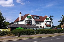 The Milton Arms pub
 -
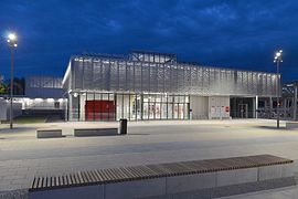 Cambridge North railway station at night
 -
 Chesterton War Memorial
 -


Notable people
- Horace Gray (1874–1938), cricketer
- Leo Reid (1888–1938), cricketer
- Veronica Volkersz (1917–2000) aviator, Air Transport Auxiliary pilot in the Second World War, first woman to fly an operational jet fighter
See also
- Chesterton Tower A medieval dwelling
- Chesterton (UK Parliament constituency) A former constituency
- Chesterton railway station Closed 1850
- Chesterton Road
- St Andrew's Church, Chesterton
References
- ^ Chisholm, Hugh, ed. (1911). . Encyclopædia Britannica. Vol. 6 (11th ed.). Cambridge University Press. p. 112.
- ^ "100 Houses Assn, Accessed 6 October 2014". Archived from the original on 19 September 2013. Retrieved 7 September 2013.
- ^ "Population statistics Chesterton AP/CP through time". A Vision of Britain through Time. Retrieved 15 January 2023.
- ^ "Relationships and changes Chesterton AP/CP through time". A Vision of Britain through Time. Retrieved 15 January 2023.
- ^ "Bus Timetables".
- ^ Helen Frame (21 May 2017). "As it happened: Passengers board the first train at Cambridge North Station". Cambridge News. Retrieved 1 December 2020.
- ^ "Cambridge Science Park station". Cambridgeshire County Council. Archived from the original on 11 November 2013. Retrieved 1 December 2020.
1 Annotation
First Reading
Grahamt • Link
Link to site:
http://www.ukvillages.co.uk/ukvil…
From here you can see a map and aerial photograph. It is now a suburb of Cambridge, and no longer the pretty village Pepys remembered.